by Neil Lawley
I have read Pascal's article and a possible solution is described below.
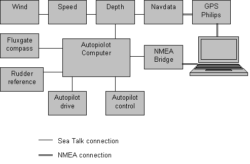
I have Autohelm ST50 instruments to measure Speed through the water, depth of water, wind (direction and speed), automatic pilot (ST6000), electronic fluxgate compass, Navdata (which is a display of GPS information) and Radar connected together via the Autohelm communication system called Sea Talk. The combination of the wind and speed instruments enables the wind instrument to calculate absolute wind speed and direction in addition to the apparent wind speed and direction, which is very useful when you are running before the wind and it feels very much less strong than it really is. The combination of wind and speed instruments enables the speed instrument to calculate velocity made good relative to the wind direction, which is useful for optimizing the speed/direction of the boat when tacking.
I have a Philips GPS connected via NMEA to the Navdata instrument and to the laptop for uploading way points and routes direct into the GPS. The combination of speed through the water and speed over ground enables the Navdata to calculate the speed and direction of the tide. The Navdata also displays Latitude and Longitude, COG and SOG, Waypoint, VMG to waypoint and clock time. The laptop is also connected to the autopilot computer via an NMEA interface box, so all the Sea Talk information and GPS data can be read on the laptop. The way all the elements of my system are connected together is shown in the figure below:
On the laptop I have PC Maritime "Navmaster Offshore" navigation system and ARCS charts. It allows the boat position to be displayed on the chart on the laptop. Which in turn allows the plotting of the track and making a log of positions, speed, and course etc. every hour or whatever you choose as an appropriate time between logs. Navmaster automatically chooses the best chart for your current position and takes care of any different chart datums from WGS84, to which you set your GPS. It allows you to display more than one chart so you can have a detailed chart for your current position and a smaller scale chart for planning.
The laptop gets its electric current direct from the ships batteries with a dc to dc transformer.
I use ARCS charts (British Admiralty), because they are the standard for shipping and are easy to correct, with CD-ROMs, yearly or quarterly, for a relatively small amount of money. So my charts are always up-to-date. I also have charts of the Dutch Hydrografische Kaart issued also by ARCS.
I use Proudman's Tidal atlas with the Navmaster Offshore, this enables tidal streams to be shown on any electronic chart on the laptop, and to allow plans to be calculated by the system to be corrected for tides. I also have a tidal height calculator "Navtides" on my laptop, which calculates the height of tides for 347 UK, and 312 European ports. It also allows you to input the draught of your boat and the depth of water at the point you will anchor and show the amount of water below the keel.
The autopilot can steer a compass course, a relative wind course and cross track error. The compass course is what it says, it steers a compass course without taking into account the tides, which will sweep you to port, or starboard. The wind does the same but this time keeps the angle between the boat and the wind constant. So if the wind veers the boat will follow it. The cross track error keeps the cross track error for the track between the last waypoint and the next one equal to zero, this then takes into account and corrects for the tide, and will maintain a straight course over the ground.
All the instrument readings including the GPS and next waypoint are visible on the Radar screen, which is positioned close to the steering wheel so it is easy to follow the Radar when it is required in anger. This is important as the Radar is used only when the visibility is poor in (fog or at night) or when it is difficult to tell if we are missing a ship. This is possible because the screen is LCD and therefore safe to use in rain. It has bearing capability and therefore you can see if you are on a collision course with another ship. It also has an electronic guard zone so that an alarm goes off when a ship enters the guarded area.
Of course I am concerned about the reliability of the laptop and GPS so I have a spare for both just in case, although I haven't had to use either spares so far and I have been using them for more than 5 years. AND, just in case, I always have paper charts on board, though not always up-to-date.
The cost of all the above is:
Navmaster Offshore package is £400.
The charts cost £82 for 10 charts.
Dutch charts cost £49 for a standard book of (about 10 plus harbours) charts
Navtides costs £55
Tidal streams costs £120 for all sea areas
Chart corrections cost £70GBP per annum for more than 30 charts including Dutch charts.
It is expensive but over 7 years I accumulated a lot and it is a very powerful system.
To keep my (3x 135 AH) batteries fully charged I have a Solar panel (Solar) and wind generator (Rutland 913) and an (Adverc) alternator control unit to give maximum voltage to the batteries.